 Alerua
Radar echoes
Why radar shows rain when it isn’t raining
Rain that dries up before the ground, birds and insects, clutter, and a picture a few minutes old.
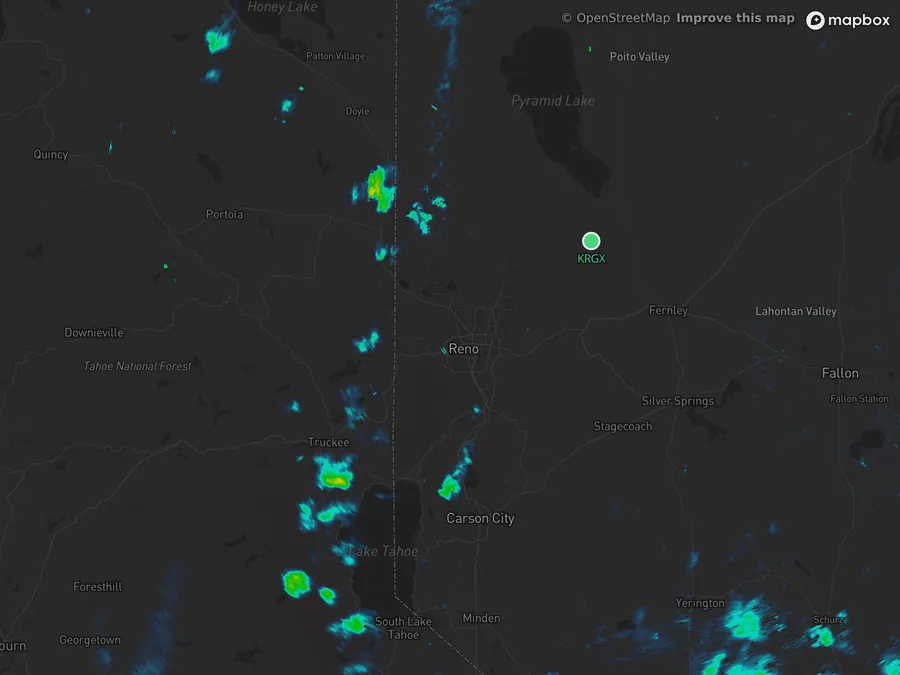
- KRGX Reno
- 1:58 PM PDT, May 2, 2026
- 0.5° · about 5,000 ft above Reno
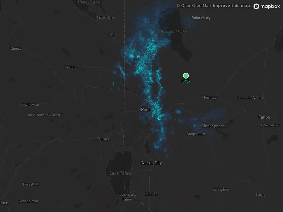
- 2:03 PM PDT
- 5.1° · about 15,000 ft above Reno
- 1Reno-Tahoe airport, which reported virga and no rain.
Rain that dries up before it lands
The radar sees raindrops wherever its beam crosses them, and the beam is not at the ground. At 40 miles the lowest beam is about 2,600 feet up, and it climbs from there. Drops falling into dry air shrink as they evaporate and can vanish thousands of feet short of the ground. The streaks hanging under such a cloud are called virga, and radar draws them as rain.
The Reno radar sits on a mountain 8,300 feet up, so its lowest tilt crosses about 5,000 feet over the airport. At 1:55 PM on May 2, 2026, the airport reported virga and no rain, with the air at 72°F and a dewpoint of 28°F. The lowest tilt shows almost nothing over the city. The tilt 10,000 feet higher shows a band of echo over it. About 40 minutes after these scans a 54 mph gust hit the airport, with a few minutes of rain too light to measure.
On Alerua the tilt is shown beside the clock, and Settings, Elevation steps through the tilts.
Birds and insects
Anything in the air sends a little energy back, and a flock of thousands sends back a lot. On a still night in spring or fall, migrating birds lift off together at dusk, and the radar draws them as a wide, round blob of blue and green around itself that grows outward from sunset. Insects do the same on summer evenings. The blob can cover a hundred miles of map while the ground under it is dry.
This is the La Crosse, Wisconsin radar at 9:33 PM on October 25, 2026, in the middle of fall migration. The airport’s 8:53 PM report had an overcast sky and no precipitation. Alerua’s Filter ground clutter switch, on by default, hides echoes whose correlation coefficient is low, which is how birds and insects read. It clears most of the bloom and leaves a speckle.
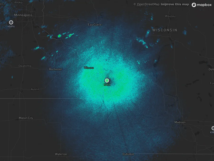
- KARX La Crosse
- 9:33 PM CDT, Oct 25, 2026
- Filter off
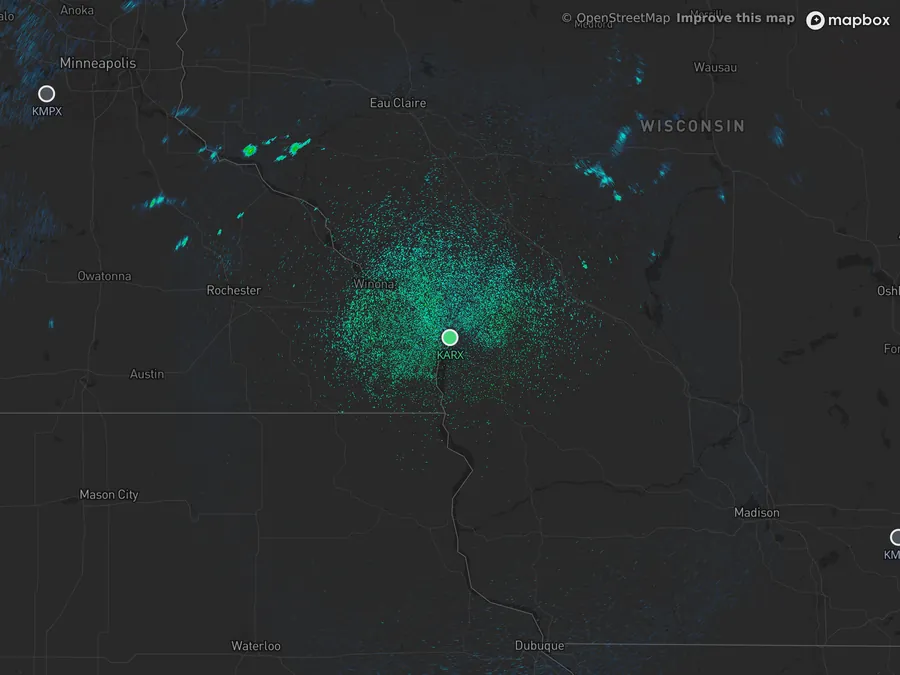
- Filter on
Clutter, wind farms and the sun
| What you see | What it usually is |
|---|---|
| A speckled patch that never moves, close to the radar | Ground clutter: the beam hitting buildings, hills and trees. It is strongest near the radar and on the lowest tilts. |
| Rain-like echoes on a calm, clear night that fade by day | Cool air near the ground bends the beam down into the ground, so hills and cities light up. Meteorologists call it anomalous propagation. |
| Small fixed dots that flicker | Wind turbines. Their spinning blades send a signal back. |
| A thin straight line pointing out from the radar at sunrise or sunset | The sun, which gives off energy at the radar’s own wavelength. |
| A smudge with no storm around it | Smoke, ash or dust lifted high enough for the beam to reach it, or a swarm of insects. |
A picture that is minutes old
A radar takes four to six minutes to finish a scan, and the frame is already older when it reaches you. A storm moving at 30 mph travels about 2½ miles in five minutes, so the rain drawn over you may already have passed. The clock on the map is when the radar finished the tilt on screen, in your own time zone, and the hourglass beside it shows how old the picture is.
Keep reading
- Dual-polarizationDual-polarization radar, explainedCorrelation coefficient, differential reflectivity and KDP, and how they tell rain from hail, debris, birds and insects.
- Winter weatherHow to tell rain from snow on radarWhy the colors look alike, how the correlation coefficient shows melting, and what the beam misses near the ground.
- Radar basicsHow to read weather radarWhat a radar measures, what the colors mean and how to read a loop.
Further reading
Radar data from NOAA’s NEXRAD Level II archive. Base map © Mapbox © OpenStreetMap contributors.