 Alerua
Severe weather
What is a derecho? Reading a bow echo
A derecho is a line of storms that keeps blowing down trees along a path hundreds of miles long. On radar the line bends into a bow, and the wind shows up on velocity.
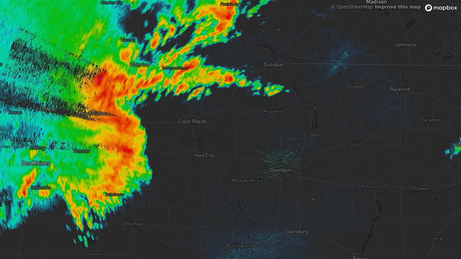
- KDVN Quad Cities, Iowa
- 12:05 PM CDT, August 10, 2020
- 0.4° tilt
- Reflectivity
- 1The bow: the middle of the line has pushed ahead of its ends.
- 2The rest of the line, running northeast.
- 3Cedar Rapids airport: a 68 mph gust at 12:30 PM.
The bow on reflectivity
A bow echo is a curved band of thunderstorms. The National Weather Service’s Storm Prediction Center says they usually form when a storm’s rain-cooled outflow is strong and moves in one direction. The middle of the line is pushed ahead of the ends, which bends it.
The picture above is the Quad Cities radar at 12:05 PM CDT on August 10, 2020. The bulge points east toward Cedar Rapids, and the line continues to the northeast. Twenty-five minutes later the airport at Cedar Rapids recorded a 68 mph gust.
The wind behind the front
Reflectivity shows rain, and the wind has to be read on velocity. Earlier that morning, at 10:28 AM, the Des Moines radar had the front about 35 miles west of the airport.
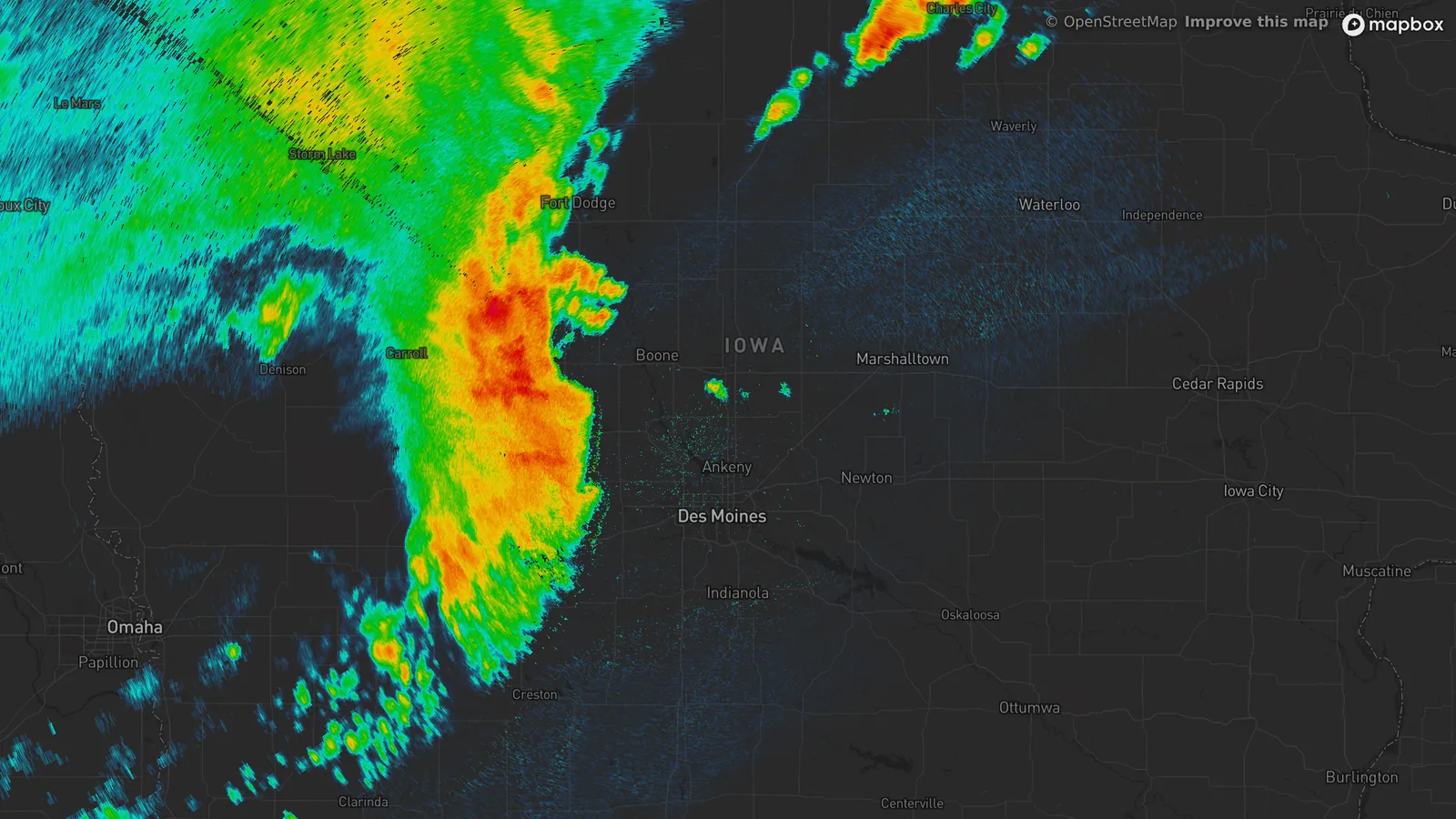
- KDMX Des Moines, Iowa
- 10:28 AM CDT, August 10, 2020
- 0.5° tilt
- Reflectivity
- 1The front, about 35 miles from Des Moines airport.
- 2Des Moines airport: a 75 mph gust at 11:00 AM.
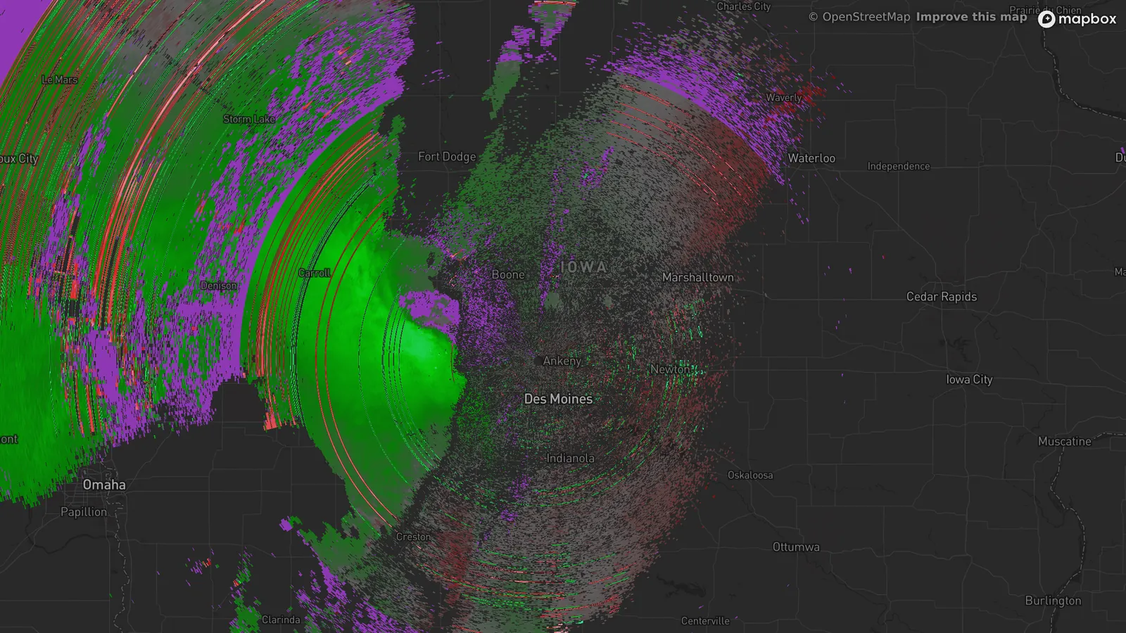
- KDMX Des Moines, Iowa
- 10:28 AM CDT, August 10, 2020
- 0.5° tilt
- Velocity
- 1Green: air moving toward the radar, the way the storm was travelling.
Behind the front the velocity map is one block of green: air moving toward the radar, the same way the storm was travelling. A tornado is a small pair of red and green side by side. Here one color fills the area behind the front.
The Storm Prediction Center calls this a rear-inflow jet: air flowing into the back of the storm, drawn in by the growing pool of rain-cooled air, which strengthens the gust front. Thirty-two minutes after that scan the front reached Des Moines airport. It was 79°F at 10:54 AM, the gust at 11:00 AM was 75 mph, and by 11:04 AM it was 65°F.
When a bow echo is a derecho
A bow echo can be a few miles across and over in twenty minutes. For a derecho the Storm Prediction Center requires a swath of wind damage at least 250 miles (400 km) long, gusts of at least 58 mph along it and several well-separated gusts of 75 mph or more, from a storm system moving faster than the average wind. It also expects bow echoes and rear-inflow jets on radar.
The August 2020 derecho affected eight states from Nebraska to Ohio. The National Weather Service in the Quad Cities says many places had 30 to 60 minutes of high wind, against 10 to 20 minutes for a typical derecho. The highest measured gust was 126 mph at Atkins, Iowa, an unofficial reading, and damage in Cedar Rapids was consistent with 130 to 140 mph.
What to look for
On reflectivity, look for a line with a bulge in the middle, moving fast. On velocity, look for a wide area of one color behind the front. In Alerua, choose Product, then Velocity, on the radar nearest you and compare it with Reflectivity at the same time.
A bow’s wind can do a tornado’s damage with no tornado at all, so a severe thunderstorm warning for one calls for the same shelter: inside, on the lowest floor, away from windows.
Keep reading
- Severe weatherHow to spot a tornado on radarThe hook echo, the rotation pair on velocity and the debris signature.
- Weather alertsWatch vs warning: what each one meansWhat a watch and a warning say for tornadoes, severe storms and floods, and how they look on a radar map.
- Doppler radarHow Doppler radar worksHow the radar measures wind, why it only sees motion toward or away, and where the reading breaks down.
Further reading
- Storm Prediction Center: derecho facts
- National Weather Service Quad Cities: the August 10, 2020 derecho
- Iowa Environmental Mesonet: surface observations archive
Radar data from NOAA’s NEXRAD Level II archive. Surface reports from National Weather Service and FAA stations via the Iowa Environmental Mesonet. Base map © Mapbox © OpenStreetMap contributors.