 Alerua
Weather alerts
Watch vs warning: what each one means
A watch means conditions are right. A warning means the hazard is happening or about to. How the two look on a map, and what to do for each.
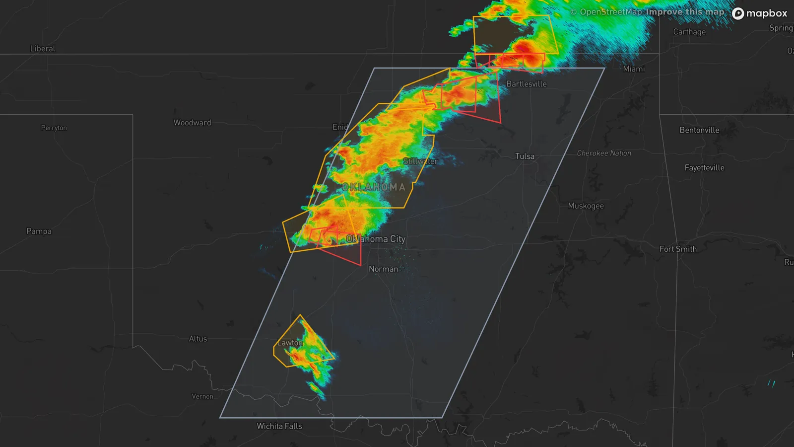
- KTLX Norman, Oklahoma
- 6:14 PM CDT, May 31, 2013
- 0.5° tilt
- Reflectivity
- 1The tornado watch.
- 2Tornado warnings, in red.
- 3A severe thunderstorm warning, in amber.
A watch: be ready
The Storm Prediction Center in Norman, Oklahoma issues watches for a cluster of counties where tornadoes or other severe weather are possible over the next several hours. The National Weather Service says a tornado watch means tornadoes are possible in and near the watch area, and that a watch often covers many counties or even several states.
The tornado watch on this map was issued at 3:30 PM and ran until 12:04 AM, about 8½ hours, over roughly 26,000 square miles of Oklahoma and north Texas. A watch says nothing about whether a storm has formed. It is the time to decide where you would shelter and how you would hear a warning.
A warning: act now
A warning comes from your local National Weather Service office and means the hazard is happening. For a tornado, one has been sighted or indicated by radar. A severe thunderstorm warning is for wind of 58 mph or more or hail 1 inch or more across. A warning covers about the area of a city or small county and lasts under an hour. The two red warnings near Oklahoma City cover about 145 and 340 square miles and ran for 39 and 52 minutes, the larger from 6:08 to 7:00 PM.
When a tornado warning covers your location, go to a windowless interior room on the lowest floor of a sturdy building. In a mobile home, a vehicle or outdoors, get to the nearest sturdy shelter.
Both on one map
The large outline is the watch, and the red and amber outlines are warnings, each drawn around the storm it is about. A warning does not need a watch: the amber severe thunderstorm warnings at the top of the map lie north of this tornado watch.
| A watch means | A warning means | |
|---|---|---|
| Tornado | Tornadoes are possible in and near the area. | A tornado has been sighted or indicated by radar. |
| Severe thunderstorm | Severe storms are possible in the next several hours. | A storm with wind of 58 mph or more, or hail of 1 inch or more, is happening or on radar. |
| Flood | Conditions are favorable for flooding, which is possible but not certain. | Flooding is happening or imminent. For a flash flood, move to high ground. |
Advisories and the rest
The National Weather Service calls an advisory a special weather condition that is less serious than a warning. A flood advisory is one example. Alerua draws warnings over the radar (Settings, then Warnings): tornado warnings in red, severe thunderstorm warnings in amber and flash flood warnings in green. Watches come from the Storm Prediction Center, and its map is at spc.noaa.gov.
Keep reading
- Severe weatherHow to spot a tornado on radarThe hook echo, the rotation pair on velocity and the debris signature.
- Severe weatherWhat is a derecho? Reading a bow echoThe bowed line on reflectivity, the block of wind on velocity, and what makes a bow echo a derecho.
- Severe weatherHow to spot hail on radarWhy a red core can be hail or heavy rain, what the two dual-pol maps add, and what radar can’t tell you about size.
Further reading
- National Weather Service: tornado watch and warning
- National Weather Service: flood watch and warning
- NOAA Storm Prediction Center: tornado FAQ
- National Weather Service glossary: advisory
- National Weather Service Indianapolis: severe weather criteria
Radar data from NOAA’s NEXRAD Level II archive. Warnings and watches from the National Weather Service and the Storm Prediction Center via the Iowa Environmental Mesonet. Base map © Mapbox © OpenStreetMap contributors.