 Alerua
Severe weather
How to spot hail on radar
A red core in reflectivity can be hail or a downpour. Two dual-pol maps tell them apart, and only reports tell you how big the hail was.
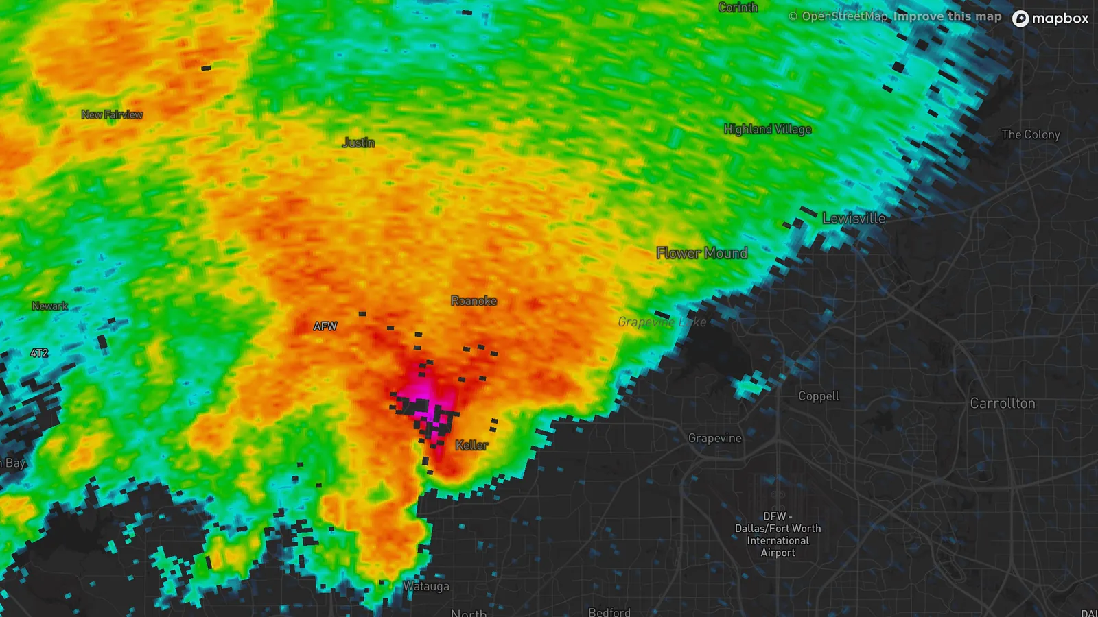
- KFWS Fort Worth, Texas
- 8:34 PM CDT, April 28, 2021
- 0.5° tilt
- Reflectivity
- 1The core, over Keller. A 3 inch hailstone was measured there at 8:37 PM.
A red core is not enough
Hail sends a lot of the radar’s pulse back, so a hail core shows up red, magenta or purple on reflectivity. So does a downpour. The National Weather Service office at Taunton, Massachusetts, says hail usually reads above 55 dBZ, and heavy rain can read high too.
At 8:34 PM CDT on April 28, 2021 the Fort Worth radar showed a small magenta core over Keller, Texas, inside a larger area of orange and red. At 8:37 PM a 3 inch hailstone was measured in Keller, and at 8:40 PM a photo showed hail a little larger than 3 inches near Roanoke.
What the two dual-pol maps add
Differential reflectivity reads positive for raindrops, which flatten as they fall, and near zero for tumbling hail, which looks round on average. The National Weather Service gives a range of −0.5 to 1.5 dB for hail. In this scan the core is gray and has gaps, and the highest values are about 5 miles east, where the rain has large drops.
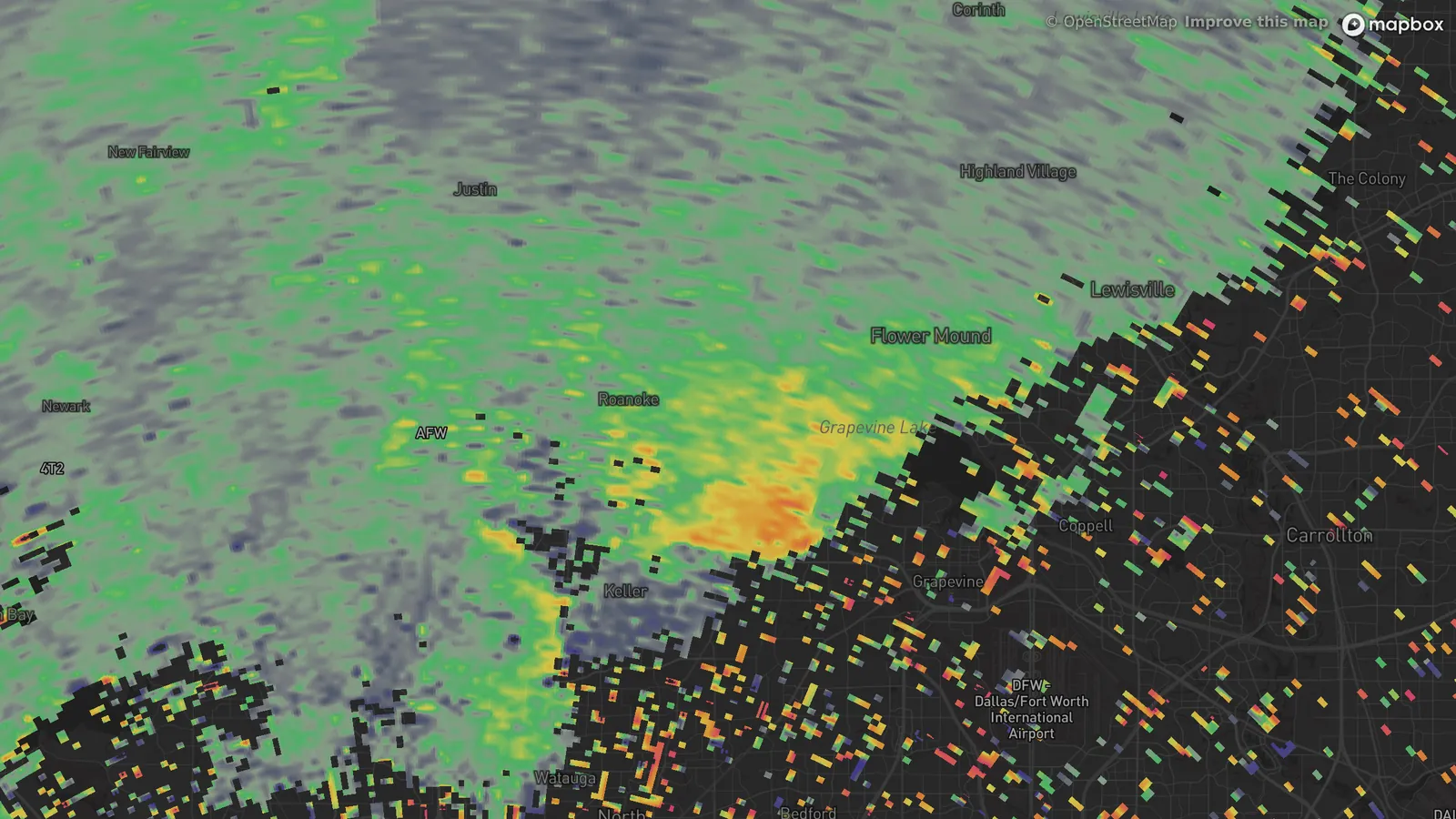
- KFWS Fort Worth, Texas
- 8:34 PM CDT, April 28, 2021
- 0.5° tilt
- Differential reflectivity
- 1Near zero at the core, where the hail is.
- 2Highest about 5 miles east, where the drops are large rain.
Correlation coefficient asks whether the radar’s horizontal and vertical echoes agree. Rain agrees and reads near 1. Hail mixed with rain does not, and the National Weather Service says the value is usually below 0.95 and can fall under 0.85 for hail 2 inches or larger. Here a patch of lower values sits around the core and nowhere else in the storm.
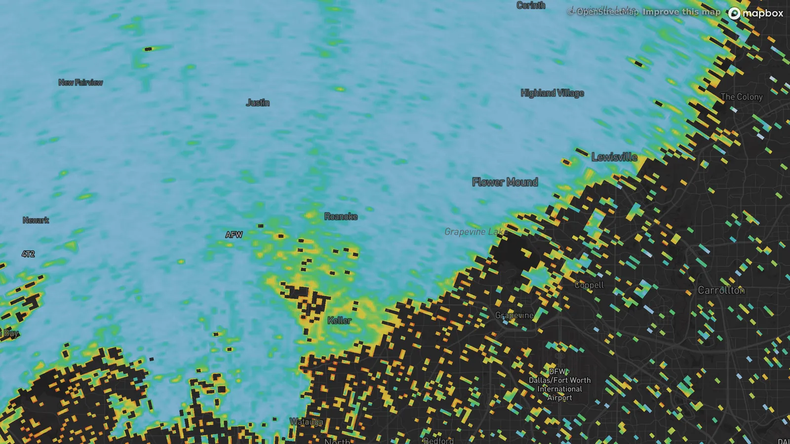
- KFWS Fort Worth, Texas
- 8:34 PM CDT, April 28, 2021
- 0.5° tilt
- Correlation coefficient
- 1Lower values around the core, where the echo is a mix.
What radar can’t tell you
The three maps said hail at 8:34 PM. They didn’t say 3 inches. A quarter, at 1 inch, has been the National Weather Service’s severe hail size since January 2010. A golf ball is 1.75 inches and a baseball is 2.75, and the hail in Keller was larger than both. Size comes from reports, from people who measured it.
The beam also sits above the ground. At the core it was about 1,800 feet up, so it sees the hail before its last stretch to the street, where it can melt. Hail also lands in a narrow path.
What to check
Look for a red or purple core in reflectivity first. Then open Differential reflectivity and Correlation coefficient on the same radar and time. A core with near-zero differential reflectivity and lowered correlation coefficient is a good sign of hail. In Alerua these are in Product, on radars that report them.
If a core like that is heading your way, go inside and stay away from windows.
Keep reading
- Dual-polarizationDual-polarization radar, explainedCorrelation coefficient, differential reflectivity and KDP, and how they tell rain from hail, debris, birds and insects.
- Severe weatherHow to spot a tornado on radarThe hook echo, the rotation pair on velocity and the debris signature.
- Severe weatherWhat is a derecho? Reading a bow echoThe bowed line on reflectivity, the block of wind on velocity, and what makes a bow echo a derecho.
Further reading
- National Weather Service Taunton: using dual-pol radar
- Storm Prediction Center: storm reports for April 28, 2021
- American Meteorological Society: NWS increases severe hail threshold
Radar data from NOAA’s NEXRAD Level II archive. Hail reports from the Storm Prediction Center’s storm reports. Base map © Mapbox © OpenStreetMap contributors.